RealityMaps: ski, hike, bike 0.1.9.250217 Apk for Android

updateUpdated
offline_boltVersion
0.1.9.250217
phone_androidRequirements
7.0
categoryGenre
Apps
play_circleGoogle Play
The description of 3D map with ski, hike and bike tours - GPS Navi
Outdoor App for Perfect Planning and Orientation on the Way
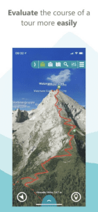
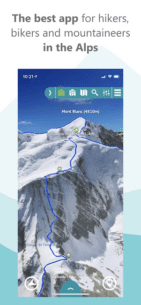
The award-winning app is the perfect tool for planning your outdoor activities. With its unique, ultra-realistic 3D representation of the mountains, you can better assess the terrain and inspire new adventures. The app offers many practical features such as GPS tracking, a route planner, a GPX import function, and map download for offline use.
Maps for Summer & Winter
Our ultra-realistic 3D maps are the most accurate in the market. We calculate these maps using innovative technology derived from aerial and satellite images. Currently, we cover the following regions:
- Alps
- Pyrenees
- Balearic Islands
- Canary Islands
- Corsica
- Mt Everest & Himalaya
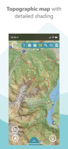
The app also provides a worldwide topographical map with unique 3D relief shading at a scale of 1:10,000 free of charge.
Quality-Certified Tours
The app offers hiking, mountain, ski, and bike tours exclusively researched by experts from Bergverlag Rother and other partners. With the built-in GPS, you can easily follow the marked route during your tour. A highlight is the ability to import any tours in GPX format or from Komoot into the 3D map.
Simple and Safe Orientation on the Move
With the combination of 3D map, aerial photo, and topographical relief map on a scale of 1:25,000, you can perfectly prepare for your trip. The routing function allows you to plan new routes on the 3D map. The GPS tracking function turns your smartphone into a full-fledged navigation device, displaying your current location live on the map. A virtual 360° panorama with information about the surrounding landscape makes navigation easier.
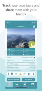
Record Your Own Tracks
With the tracking function, you can record your track and display the route covered live on the 3D map. Duration, distance, altitude, and speed are continuously monitored. With a user account, you can save the recorded tracks in your personal tour cloud, transfer your tracks to other smartphones or tablets, and share them with friends.
More Safety in the Mountains - Offline Maps
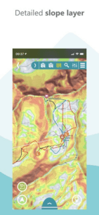
The app offers an unprecedented level of security. In the photo-realistic 3D map, you can read the exposure and condition of the terrain, identifying potential danger spots. In bad weather, fog, or at night, you can still navigate effectively as the map depicts the real terrain. Another safety feature: you can load the maps onto your smartphone for offline use.
Exclusively for Premium Users
With a PREMIUM subscription, you can record, save, share, and transfer your tracks to other devices, save maps offline on your smartphone, import tours in GPX format and from Komoot, and plan tours in 3D. This subscription supports the further development of the app and the creation of the 3D maps. The subscription runs through the store and can be canceled at any time.
Free Trial Subscription
With a test subscription, you can use all PREMIUM functions for one week free of charge.
For more information, visit Reality Maps App.
Terms and Conditions: View here.
What's news
- Planning routes is now even easier
- Over 10,000 new tours
- Faster app launch
- Full integration of the new Tour Planner for the PC
- Plan with the Tour Planner for the PC directly on the 3D map
Download 3D map with ski, hike and bike tours - GPS Navi
Download the shared installation file of the program with a direct link - 167 MB
.apk


 252 Apk for Android 12")
 1.6.42 Apk for Android 13")

 2.3.0 Apk for Android 15")


