AlpineQuest Off-Road Explorer 2.3.9 Apk for Android
updateUpdated
offline_boltVersion
2.3.9
phone_androidRequirements
2.1
categoryGenre
Apps, GPS
play_circleGoogle Play
The description of AlpineQuest Off-Road Explorer
Discover the Ultimate Outdoor Companion: AlpineQuest
AlpineQuest is your all-in-one solution for various outdoor activities and sports, including:
- Hiking
- Running
- Trailing
- Hunting
- Sailing
- Geocaching
- Off-road navigation
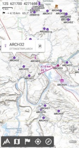
With AlpineQuest, you can access and store a wide range of online topographic maps locally, ensuring that they remain available even when you're out of cell coverage. The app also supports numerous on-board file-based raster map formats.
Stay Oriented and Safe
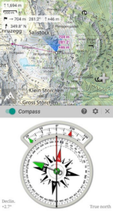
Utilizing your device's GPS and magnetic sensor, along with a compass display, getting lost will be a thing of the past. You can view your real-time location on the map, which can be oriented to match your line of sight.
Feature-Rich Experience
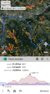
Save and retrieve an unlimited number of placemarks and share them with friends. Track your path, obtain advanced statistics, and enjoy interactive graphics. You'll never have to wonder about your outdoor accomplishments again.
Explore the Wilderness
AlpineQuest remains fully operational outside of cell coverage, making it the perfect companion for deep wilderness exploration.
Privacy First
No advertisements, no data sharing, no monetization, no analytics, and no third-party libraries.
Try It Now!
Don't hesitate to try the free Lite version right now!
Please report any suggestions or issues on our dedicated forum (no registration needed, all questions answered) instead of in the comments.
Key Features of AlpineQuest
★★ Maps ★★
- Built-in online maps with automatic local storage, including road, topo, and satellite maps.
- Access additional online maps and layers with one click from the community maps list.
- Complete area storage of online maps for offline use.
- Support for various offline map formats, including KMZ Overlays, OziExplorer formats, GeoTiff, and more.
- Built-in image calibration tool to use any scan or picture as a map.
- Digital elevation model storage and support for HGT elevation files.
- Polar maps support for Arctic and Antarctic regions.
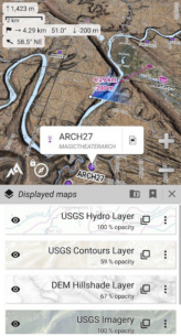
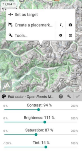
- Display multiple maps in layers with customizable opacity, contrast, color, and blending controls.
★★ Placemarks ★★
- Create, display, and save an unlimited number of items like waypoints, routes, and tracks.
- Import/export GPX, KML/KMZ, CSV/TSV files, and more.
- Save and share online locations using Community Placemarks.
- Access detailed statistics and interactive graphics for various items.
- Replay time-tagged tracks using the Time Controller.
★★ GNSS Position / Orientation ★★
- On-map geolocation using GNSS receivers or network.
- Map orientation, compass, and target finder features.
- Built-in GNSS/Barometric track recorder with battery and network strength recording.
- Proximity alerts and leave path alerts for enhanced safety.
- Barometer support for compatible devices.
★★ Additional Features ★★
- Support for metric, imperial, nautical, and hybrid distance units.
- Multiple latitude/longitude and grid coordinate formats with on-map grids display.
- Ability to import hundreds of coordinate formats from spatialreference.org.
What's news
2.3.9d
• Added tap screen then move up/down zooming;
• Added UTM coordinates in feet;
• Various improvements and bug fixes.
2.3.9a/b/c
• Added ability to set coordinate systems as favorite;
• Added ability to display photos of all recorded tracks as previews over the map (“Placemarks” menu → “Displayed placemarks” → tap the eye at the right of “Photos”);
• Added ability to view the EXIF information of photos;
• Sunrise and sunset times are given in both device and screen-center time zones.
Download AlpineQuest Off-Road Explorer
Download the paid installation file of the program with a direct link - 8 MB
.apk


