Avia Maps Aeronautical Charts 3.17.2 Apk for Android

updateUpdated
offline_boltVersion
3.17.2
phone_androidRequirements
8.0
categoryGenre
Apps, GPS
play_circleGoogle Play
The description of Avia Maps Aeronautical Charts
A Reliable Aviation Map App for Pilots and Enthusiasts
Introducing a dependable and user-friendly aviation maps application designed for pilots and aerospace enthusiasts worldwide. This app is perfect for both pre-flight planning and in-flight navigation.
Key Features
- Customizable Area Selection: Choose any
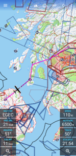
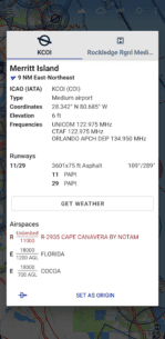
5 by 5 degreearea on Earth to download relevant data for offline use. - Extensive Database: Access information on over 65,000 airports, 9,000 navaids, and 15,000 waypoints globally, including airspaces for 62 countries across all continents (except Antarctica).
- Countries Covered: The app includes airspace data for the United States, Canada, Europe, Australia, and New Zealand.
Weather Forecasts
Stay updated with global, high-resolution weather forecasts from the German DWD and US NOAA. The app provides accurate map layers for:
- Cloud cover
- Ceiling
- Precipitation
- Wind on the ground and aloft
Data is downloaded onto your device, allowing you to check forecasts even during flights without cell reception. The app integrates with Avia Weather to retrieve the latest METAR and TAF at your destination airport.
Digital Elevation Model
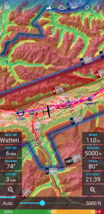
A digital elevation model aids in planning your route through mountainous areas. During flight, the terrain overlay dynamically colors hills and mountains on the map based on your current altitude, enhancing your situational awareness.
Traffic Information
Enhance safety with traffic information displayed directly on the map from your favorite ADS-B receiver or the SafeSky app. The app supports traffic data reception using the GDL90 format, compatible with most portable ADS-B receivers like SkyEcho or Stratux. If you lack a receiver, SafeSky can provide traffic data using just an internet connection.
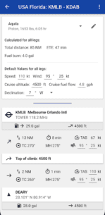
Performance Calculations
For the most accurate performance calculations, create multiple aircraft profiles based on handbook values for climb performance, fuel consumption, and more. Route calculations utilize these profiles, considering engine type and fuel burn for climb performance, employing common formulas used in aerospace engineering. With just four carefully chosen data points, the app can accurately recreate the climb performance diagram found in your POH.
Map Design and Synchronization
For clarity and consistency with paper charts, the map is themed in the style of ICAO Annex 4 (Aeronautical Charts). If you use the app on multiple devices, you can easily synchronize your routes, aircraft profiles, and user waypoints between them.
Trial and Subscription
This is a trial app with full features available for 30 days. After the evaluation period, you can purchase a perpetual license from within the app or subscribe to the professional tier.
Download the app today and elevate your flying experience!
What's news
NEW: Dark/Night theme. You can choose when to activate it (automatically by the system or manual), as well as the night map theme via the in-app settings.
Bugfix: Clear route highlighting when closing the route.
Bugfix: Deadlock in check route dialog in case of invalid airspace data. (Some CTR had identical top and bottom height. The data error is now corrected.)
Bugfix: Input fields at the bottom of the screen will no longer be hidden behind the keyboard.
Download Avia Maps Aeronautical Charts
دانلود فایل نصبی اشتراکی برنامه با لینک مستقیم - 42 مگابایت
.apk


 2.5.2 Apk for Android 9")
 2.9.5 Apk for Android 10")
 1.4.19.b Apk for Android 11")

 13.8.0 Apk for Android 13")
 3.4 Apk for Android 14")

 2.23 Apk for Android 16")


 1.58 Apk for Android 19")