OsmAnd+ — Maps & GPS Offline 5.0.6 Apk for Android

updateUpdated
offline_boltVersion
5.0.6
phone_androidRequirements
7.0
categoryGenre
Apps, GPS
play_circleGoogle Play


The description of OsmAnd+ — Offline Maps, Travel & Navigation
Discover OsmAnd+: Your Ultimate Offline Navigation Tool
OsmAnd+ is a powerful offline world map application that utilizes OpenStreetMap (OSM) data. This app enables users to navigate efficiently, taking into consideration preferred roads and vehicle dimensions. You can plan routes based on inclines and record GPX tracks without the need for an internet connection. Best of all, OsmAnd+ is open source, ensuring that user data is not collected, allowing you to control what information the app accesses.
Main Features of OsmAnd+
- OsmAnd+ Privileges (Maps+)
- Support for Android Auto
- Unlimited map downloads
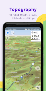
- Topo data including contour lines and terrain
- Nautical depths
- Offline access to Wikipedia
- Offline travel guides via Wikivoyage
Map View
- Customizable display of places on the map: attractions, dining, healthcare, and more
- Search functionality by address, name, coordinates, or category
- Various map styles tailored for different activities, including:
- Touring view
- Nautical map
- Winter and ski maps
- Topographic maps
- Desert and off-road maps
- Shading relief with optional contour lines
- Ability to overlay multiple map sources
GPS Navigation
- Route plotting without an internet connection
- Customizable navigation profiles for various vehicles, including:
- Cars
- Motorcycles
- Bicycles
- 4x4 vehicles
- Pedestrians
- Boats
- Public transport
- Route modification options to exclude specific roads or surfaces
- Customizable information widgets displaying:
- Distance
- Speed
- Remaining travel time
- Distance to next turn
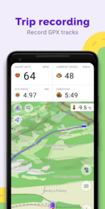
Route Planning and Recording
- Point-by-point route plotting using one or multiple navigation profiles
- GPX track recording capabilities
- Management of GPX tracks, including display and navigation
- Visual data representation of routes, including descents and ascents
- Option to share GPX tracks on OpenStreetMap
Creation of Points with Different Functionalities
- Favorites
- Markers
- Audio/video notes
OpenStreetMap Integration
- Edit OSM directly
- Map updates every hour
Additional Features
- Compass and radius ruler
- Mapillary interface
- Nautical depths
- Offline Wikipedia access
- Offline Wikivoyage travel guides
- Night theme for easier navigation
- A large community of users for support and documentation
Paid Features: OsmAnd Pro Subscription
- OsmAnd Cloud for backup and restore
- Cross-platform functionality
- Hourly map updates
- Weather plugin
- Elevation widget
- Customizable route line
- Support for external sensors (ANT+, Bluetooth)
- Online elevation profile
With its extensive features and user-focused design, OsmAnd+ is the perfect companion for adventurers and travelers alike. Download it today and experience the freedom of offline navigation!
How to install OsmAnd+ — Offline Maps, Travel & Navigation
Note: The universal version is for all processors.
What's news
• Discover top-ranked POIs with the new Explore mode
• All OSM routes, now searchable! Hiking, cycling, MTB, and more
• New navigation widget combines turn arrow and navigation instructions
• Current route info widget: displays ETA, arrival time, and distance
• Select ski slopes and MTB trails on the map for detailed information
• Ability to select widget size for left and right panels
• Added "Coordinates grid" with geographical coordinates
Download OsmAnd+ — Offline Maps, Travel & Navigation
Download the paid universal installation file with a direct link - 340 MB
.apk
Download the paid installation file Armeabi-v7a with a direct link - 170 MB
.apk
Download the paid installation file Arm64-v8a with direct link - 183 MB
.apk
Top games


Top apps


 13.8.5 Apk for Android 11")

 (PRO) 12.55 Apk for Android 13")
RELATED

TikTok 17.6.3 Apk + Mod for Android
#• Zone restrictions removed.
The problem of displaying Iranian users' posts in Timeline has been resolved.

 1.8.2 Apk for Android 16")


