Planimeter – GPS area measure | land survey on map 5.3.1 Apk for Android

updateUpdated
offline_boltVersion
5.3.1
phone_androidRequirements
4.0.3+
categoryGenre
Apps, GPS
play_circleGoogle Play
The description of Planimeter - GPS area measure | land survey on map
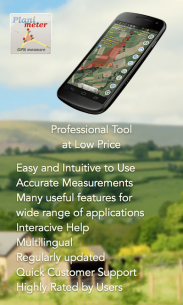
Planimeter: The Ultimate Land Surveying Tool
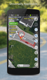
Planimeter is the best land surveying app and field area measurement tool available today. With this app, you can easily measure distance, perimeter, bearing, angle, and GPS coordinates in various formats using Google Maps. You can also save, edit, label, view, and share your measurements as KML data files and screenshots.
For a comprehensive understanding of how to determine square footage and explore all features, check out the Free Planimeter Guide.
Unique Features of Planimeter
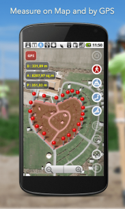
- Live Auto Map Measurement: Utilize GPS tracking to measure boundaries while walking or driving, with customizable time intervals and accuracy settings.
- Magnifying Glass: Achieve precise pin placement for distance and area measurement. Watch a demo here.
- Distance and Bearing Feature: Add points with exact distance and angle input. Learn more here.
- KML Creation and Sharing: Create, share, and view KML files directly from email attachments or file browsers. More details here.
- Notes Mode: An intuitive way to add labels (available in an extra paid mode). More info here.
- Quick Share and Navigation: Easy directions and navigation to selected points from Notes Mode (available in an extra paid mode). More details here.
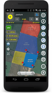
- Smart Features: Automatically remove redundant points and generate convex areas.
- Geo-Coordinate Formats: Support for various geo-coordinate formats.
- Google Earth Integration: Quick switch and view measured paths and polygons in the pre-cached Google Earth app (extra paid feature).
- Multiple Area Measurements: Available through in-app purchases. Explore more here.
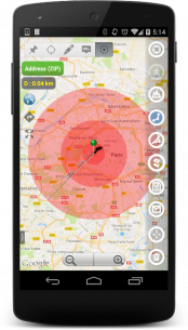
- Circle Mode: Create a radius around a point (in-app purchase). More info here.
- Volume/Cost Calculator: Calculate volume or costs when height or rate per area unit is entered. Learn more here.
Multilingual Support
The app is available in multiple languages, including English, Portuguese, Russian, German, and Italian.
User Testimonials
Planimeter has received numerous positive comments from users and has been effectively utilized in various fields:
- Outdoor Activities: Ideal for sports, golf (measuring distances between points), bike tours, trail planning, and travel.
- Garden and Yard: Perfect for landscape planning, lawn care, mowing, and fencing.
- Agriculture: Useful for harvesting, fertilizing, crop planning, and field area measurement.
- Solar Energy: Estimate areas for solar panels and flat roofs.
- Construction: Assist with land surveys, road sealing, and parking lot repairs.
- Forestry: Map objects and trees, and estimate damage areas.
- Other Applications: Measure pond sizes, plan pole lines, track movements, and obtain precise GPS coordinates.
Stay Updated
For more information about the app, tips, and updates, visit this link.
What's news
5.3.2 Italian version fix
5.3.1 Android 10 fix
5.1 Cirlces (IAB) and Volume https://goo.gl/dkHuvy
5.0 Multiple areas (IAB) https://goo.gl/SrFMj3
4.6 multi-point navigation Google Maps http://goo.gl/3dUa2p
4.5 open KML http://goo.gl/2cdI8w
4.4 German: http://goo.gl/11U4nu
4.3 Distance and Brg feature): http://goo.gl/8XbhJU
4.2 share location in Notes Mode: http://goo.gl/lCVkbq
4.1 Quick nav to point http://goo.gl/nCRTQi
4 Notes Mode (IAB) http://goo.gl/s52VdU
3.8.9 Guide http://goo.gl/EIpR5M
Download Planimeter - GPS area measure | land survey on map
Download the paid installation file of the program with a direct link - 8 MB
.apk


 2.5.2 Apk for Android 9")
 2.9.5 Apk for Android 10")
 1.4.19.b Apk for Android 11")

 13.8.0 Apk for Android 13")
 3.0.5 Apk for Android 14")


 4.17.0 Apk + Mod for Android 18")
